Water Resources Conservation
Water Resources Conservation
Water Resources Conservation
DCAP’s work on Water Resources Conservation is rooted in the landscapes of Western Uttar Pradesh, a region profoundly shaped by the ecological consequences of Green Revolution–era agricultural practices. Decades of intensive cultivation—particularly water-intensive crops such as sugarcane—combined with excessive chemical inputs have led to severe groundwater depletion. Several districts in the region have now been classified as “dark zones” by the Central Ground Water Board, indicating critical levels of groundwater over-extraction.
In response, DCAP has advanced a regenerative, landscape-based approach to water stewardship, anchored in two complementary interventions:
Reviving Surface Water Systems for Groundwater Recharge
DCAP has focused on the restoration of traditional surface water bodies (Johads) as decentralized rainwater-harvesting structures. By rejuvenating these historically embedded systems, the programme strengthens groundwater recharge, enhances seasonal water availability, and reconnects communities with indigenous water-management practices that are resilient, low-cost, and ecologically grounded.
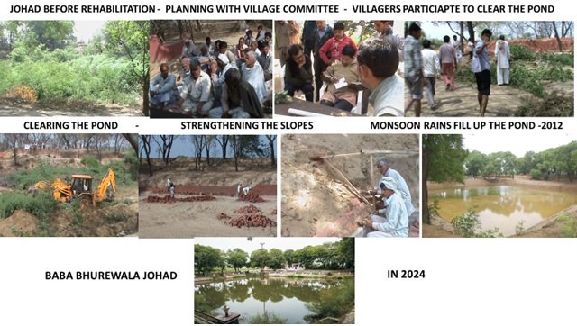
The rehabilitated Baba Bhurewala Johad in Dhikoli Village Baghpat District.
Pollution Mitigation through Nature-Based Wastewater Treatment
To address growing water pollution, DCAP initiated a pioneering natural wastewater treatment project in Dhikoli Village, Baghpat District, Uttar Pradesh. Implemented in partnership with BPCL and Natural Solutions, Mumbai, the project employs Reed Bed Systems (constructed wetlands) as an eco-friendly alternative to conventional sewage treatment.
These systems harness anaerobic, facultative, and aerobic microbial processes to treat sewage and wastewater without chemical inputs or high energy demand. As the first initiative of its kind in the district, the project sets a benchmark for nature-based technologies that simultaneously mitigate pollution, recover water quality, and rejuvenate local ecosystems.
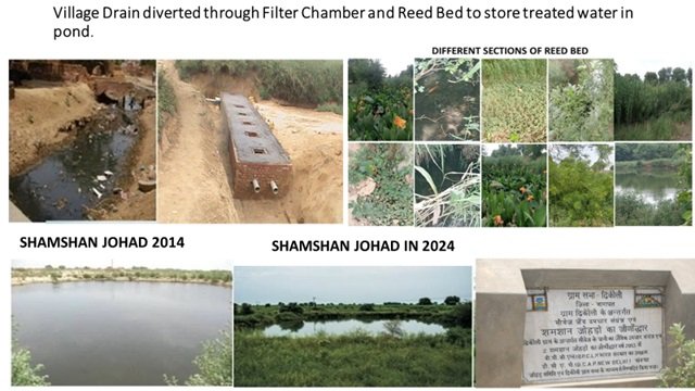
Treated Sewage collected in Johad
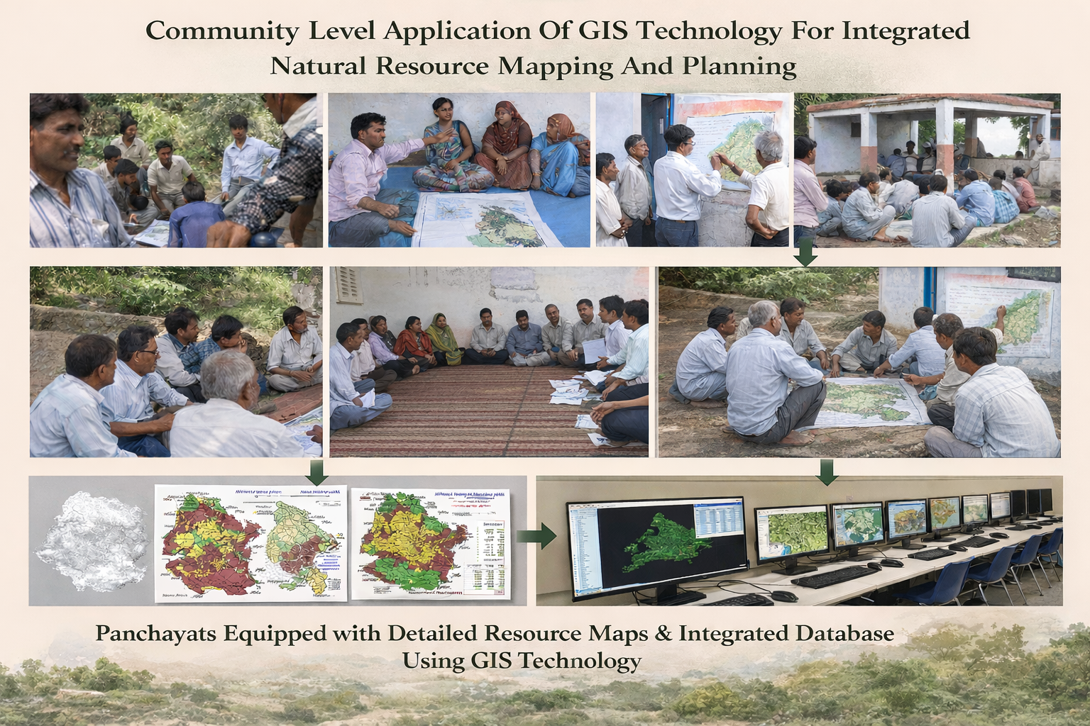
Community level Application of GIS Technology for Integrated Natural Resource Mapping and Planning
DCAP’s approach to planning begins with understanding landscapes as living systems. Decentralized Natural Resource Mapping (DNRM) is a participatory, community-based approach to the identification, documentation, and management of natural resources such as water bodies, forests, grazing lands, soil types, minerals, and biodiversity at the local level. It emphasizes local ownership, indigenous knowledge, and local environmental decision-making, and it often serves as a foundational step for strengthening biocentrism.
Building on this philosophy, DCAP initiated a pioneering project in Takula Block, Almora District (Uttarakhand), to bring Geospatial Information System (GIS) technology to local communities for decentralized, participatory Resource Mapping and Planning. While GIS in India has largely benefited national and state -level governance and business, this project aimed to empower local bodies—particularly Panchayati Raj Institutions—to prepare development plans (annual and five-year) focused on Integrated Natural Resource Management, especially water resource conservation and the revival of the non-glacial Kosi River.
Key Features and Achievements:
- Conducted a Participatory Inventory of natural resources, demographics, and infrastructure in all 175 villages of Takula Block, Almora District.
- Digitized cadastral maps at 1:1000 scale for 175 villages.
- Created comprehensive GIS-based maps:
- 175 Village Resource & Planning Maps
- 89 Gram Panchayat Maps
- 7 Nyaya Panchayat Maps
- 1 Block Map
- Integrated database covering 45 main and 133 sub-parameters across demography, infrastructure, natural resources, and development needs.
- Developed thematic maps on natural resource issues at the block level, linked to individual village maps and datasets.
- Outputs are actively used by revenue villages and shared with local administration. The data has been uploaded to the National Spatial Data Infrastructure (NSDI) website, GoI